A record-breaking storm that swept through California in recent days was made worse by climate change, experts say.
And not just because of additional rainfall that’s a symptom of a warmer climate. Adding to the misery was what preceded the deluge: months of dry conditions and devastating wildfires.
That seesaw in weather conditions—from bone dry to sopping wet—is a taste of what’s to come as the Earth heats up, scientists say.
On supporting science journalism
If you're enjoying this article, consider supporting our award-winning journalism by subscribing. By purchasing a subscription you are helping to ensure the future of impactful stories about the discoveries and ideas shaping our world today.
The volatility carries an additional danger. The storm triggered several rock slides and mudflows when sheets of rain hit parts of California that had been stripped bare by repeated wildfires.
“The record-setting precipitation in Northern California follows near-record dry conditions,” said Alex Hall, director of the Center for Climate Science at UCLA’s Institute of the Environment & Sustainability. “It is an example of the type of increasing variability in precipitation, and swings between dry and wet, that we expect with a warming climate.”
The water blast came via an atmospheric river, a band of wet air from the Pacific Ocean powered by strong winds.
While that phenomenon isn’t new, the storms now contain more water in part because a warmer atmosphere can hold more moisture, said Alexander Gershunov, a research meteorologist at the Scripps Institution of Oceanography at the University of California, San Diego.
“Atmospheric rivers certainly are more potent with warming, in a warmer atmosphere and over a warmer ocean,” Gershunov said. “There’s more moisture in warmer atmospheric rivers, and this is a particularly warm one.”
As the climate continues to warm, he said, “atmospheric rivers will become more moist, more potent and produce more precipitation.”
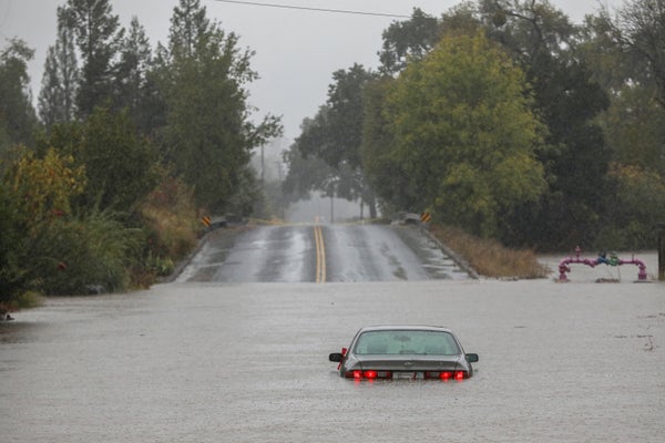
Storms started in Northern California over the weekend, moved down the coast, and then hit Los Angeles and San Diego. Before heading south, the storms caused widespread havoc. Flooding was reported across the San Francisco Bay Area, closing streets in Berkeley, inundating Oakland’s Bay Bridge toll plaza and causing rivers to overflow in Napa and Sonoma counties.
About 782,000 San Francisco-based Pacific Gas and Electric Co. customers lost power because of the weather, a number that’s about 14 percent of the utility’s 5.5 million electric ratepayers. Most have been restored.
The National Weather Service called preliminary rainfall totals from the storm “staggering.” Four inches fell Sunday in downtown San Francisco, making it the fourth-wettest day on record for the city.
“It’s been a memorable past 24 hours for the Bay Area as the long talked-about atmospheric river rolled through the region,” the local weather office said Monday. “We literally have gone from fire/drought conditions to flooding in one storm cycle.”
Northeast of San Francisco, 5.44 inches fell on downtown Sacramento, shattering the one-day record for rainfall that had stood since 1880. Along the state’s central coast, nearly 5.4 inches of rain hit California Polytechnic State University in San Luis Obispo County.
Interstate 80, the major highway through the Sierra Nevada to Reno, Nev., was closed by heavy snow early Monday. In California’s Colusa and Yolo counties, state highways 16 and 20 were shut for several miles because of mudslides, the state Department of Transportation said.
The same storm system also slammed Oregon and Washington, causing power outages affecting tens of thousands of people. Two people were killed when a tree fell on a vehicle in the greater Seattle area.
Rock slides hit numerous burn scars in state
California’s 2021 water year, which ended Sept. 30, was the second-driest on record. The storms made a dent in the drought, albeit a small one.
The water level in Lake Shasta, the state’s biggest reservoir, rose to 22 percent of capacity yesterday. The next two biggest, Lake Oroville and Trinity Lake, both hit 27 percent of capacity yesterday after the rainfall.
The rains also triggered rock slides and mudflows on numerous burn scars, places where climate change-accelerated wildfires wiped out swaths of nearly everything above ground.
Debris flows often are fast-moving torrents carrying massive boulders, soil, trees and other objects, and are considered more dangerous than mudslides or landslides (Greenwire, Jan. 27).
“In the last two years, we’ve burned, like, 6 million acres. So that’s 6 percent of California,” a state covering about 100 million acres, said Michael Wara, director of Stanford University’s Climate and Energy Policy Program. “That’s a lot of burn scar. And a lot of it burned at high intensity. So that means it’s really like denuded landscape. And that creates risk during winter rain events.”
Multiple rock slides hit the area where the Dixie Fire burned, in Butte and Plumas counties. It prompted the California Highway Patrol to close a stretch of State Route 70.
Local sheriff’s offices ordered evacuations in several places where wildfires have occurred, including parts of Santa Cruz County scorched by last year’s CZU Lightning Complex fires, and parts of western Santa Barbara County, burned by this month’s Alisal Fire.
A January 2018 debris flow in Montecito, near Santa Barbara, killed 23 people. That followed the massive 2017 Thomas Fire in the region.
“When an intense fire has gone through an ecosystem ... it basically burns off the vegetation, whose roots hold the soil together on steep slopes,” said Gershunov, the Scripps scientist.
It also makes the soil water-repellent, he said.
“And as all that water generated by an atmospheric river comes down that burn scar, it takes everything with it,” Gershunov said.
Without the burn scar, he said, “a lot of the precipitation would be absorbed by the dry soil.”
Many of the burn scars are next to California’s water supply reservoirs, including Lake Oroville, Wara said. The area around that man-made lake burned in the Bear Fire last year and the Dixie Fire earlier this year.
“So you worry about water supply being interfered with in some way, like if there was a big ash flow into one of the reservoirs, and that could cause problems,” Wara said.
This storm happening in the fall means the water could go in near-empty reservoirs, Wara said. But storms that hit in winter, if reservoirs are full, can trigger a crisis like the one that hit Lake Oroville in 2017.
Water filled the reservoir, then a series of structural failures spawned fears that the dam’s concrete spillway would collapse, sending a 30-foot wall of water downstream and causing catastrophic flooding (Climatewire, Feb. 14, 2017).
Storms that deliver precipitation in the form of rain and not snow also mean "it runs off in the winter; it doesn’t keep the soil as moist or wet as long into the season, until the dry season,” Wara said.
“That’s part of the feedbacks from [global] warming,” he added. “It’s warmer in the winter and less snow ... then you dry out faster in the summer” without the low snowmelt, “which means you get to fire conditions sooner” in the state’s Sierra Nevada region “because it’s warmer, and a positive feedback loop.”
The Associated Press contributed.
Reprinted from E&E News with permission from POLITICO, LLC. Copyright 2021. E&E News provides essential news for energy and environment professionals.